The best drone for land surveying combines long flight time, high-resolution cameras, and precise positioning systems like RTK or PPK. These drones are widely used in construction, agriculture, mining, and urban development. With the ability to collect georeferenced data efficiently, drones have become essential tools for modern-day surveyors.
Land surveying has transformed significantly with the rise of drone technology. Traditional methods were time-consuming and often required large teams to cover expansive terrain.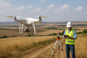
Now, drones equipped with advanced sensors and GPS systems offer a faster, safer, and more accurate way to map and analyze land.
In this article, find 20 Best Drone For Land Surveying that offer exceptional performance, from compact models ideal for small sites to heavy-duty systems designed for large-scale professional projects.
20 Best Drone For Land Surveying
1. DJI Matrice 350 RTK – Best Drone for Land Surveying with LIDAR Technology
The DJI Matrice 350 RTK stands out as a premier choice for land surveying professionals requiring LIDAR capabilities. Equipped with advanced RTK technology, it ensures centimeter-level accuracy, essential for precise topographic mapping. Its robust design and compatibility with various payloads make it versatile for diverse surveying tasks.

With a flight time of up to 55 minutes, the Matrice 350 RTK allows for extended missions, reducing the need for frequent battery changes. Its IP45 rating ensures reliable operation in challenging environmental conditions, including rain and dust. The drone’s ability to carry multiple sensors simultaneously enhances its efficiency in data collection.
The integration of the Zenmuse L1 LIDAR sensor with the Matrice 350 RTK provides high-precision 3D data, crucial for detailed terrain analysis. This combination is particularly beneficial for large-scale infrastructure projects and environmental monitoring. Overall, the Matrice 350 RTK is a powerful tool for professionals seeking advanced land surveying solutions.
Pros:
-
High-precision RTK
-
Extended flight time
-
Weather-resistant design
-
Versatile payload options
-
Advanced obstacle avoidance
-
Long transmission range
-
Robust construction
Cons:
-
High cost
-
Requires specialized training
-
Bulky for transport
2. DJI Phantom 4 RTK – Affordable Drone for Land Surveying on a Budget
The DJI Phantom 4 RTK offers an economical solution for land surveyors without compromising on accuracy. Its integrated RTK module provides real-time, centimeter-level positioning data, enhancing the precision of aerial maps. The drone’s compact design and user-friendly interface make it accessible for both beginners and seasoned professionals.
Equipped with a 1-inch 20MP CMOS sensor, the Phantom 4 RTK captures high-resolution images essential for detailed surveying. Its mechanical shutter eliminates rolling shutter distortion, ensuring accurate data collection during flight. The drone’s compatibility with the D-RTK 2 Mobile Station further enhances its positioning accuracy.
With a flight time of approximately 30 minutes, the Phantom 4 RTK is suitable for small to medium-sized surveying projects. Its affordability and precision make it a popular choice among surveyors seeking cost-effective solutions without sacrificing quality.
Pros:
-
Cost-effective
-
High-resolution imaging
-
Integrated RTK module
-
User-friendly interface
-
Compact design
-
Mechanical shutter
-
Reliable performance
Cons:
-
Limited flight time
-
Not ideal for large areas
-
Fewer payload options
3. DJI Mavic 3 Enterprise – Top-Rated Drone for Land Surveying Under $1000
The DJI Mavic 3 Enterprise combines affordability with professional-grade features, making it a top choice for budget-conscious surveyors. Its 4/3 CMOS 20MP sensor delivers exceptional image quality, crucial for accurate land mapping. The drone’s lightweight and foldable design ensures easy transportation and quick deployment in the field.

With a maximum flight time of 45 minutes, the Mavic 3 Enterprise allows for extensive coverage in a single mission. Its RTK module provides precise positioning data, reducing the need for ground control points. The drone’s advanced obstacle sensing system enhances flight safety, especially in complex environments.
The Mavic 3 Enterprise’s compatibility with DJI’s suite of software tools facilitates efficient mission planning and data processing. Its affordability, coupled with professional capabilities, makes it an excellent entry-level option for land surveying tasks.
Pros:
-
Affordable price
-
High-quality imaging
-
Extended flight time
-
Compact and portable
-
Integrated RTK module
-
Advanced obstacle sensing
-
User-friendly software
Cons:
-
Limited payload capacity
-
Not suitable for heavy-duty tasks
-
Less customizable
4. DJI Matrice 300 RTK – Professional Drone for Land Surveying and Construction Sites
The DJI Matrice 300 RTK is engineered for demanding surveying and construction applications, offering unparalleled performance and versatility. Its ability to carry multiple payloads, including LIDAR and thermal sensors, makes it adaptable to various project requirements. The drone’s robust construction ensures reliability in challenging environments.
With a flight time of up to 55 minutes, the Matrice 300 RTK enables extensive data collection in a single sortie. Its advanced AI capabilities, such as Smart Track and PinPoint, enhance operational efficiency and accuracy. The drone’s IP45 rating ensures protection against dust and water, making it suitable for harsh conditions.
The Matrice 300 RTK’s integration with the Zenmuse P1 and L1 payloads provides high-resolution photogrammetry and LIDAR data, essential for detailed surveying. Its comprehensive safety features, including obstacle avoidance and redundancy systems, ensure secure operations.
Pros:
-
High payload capacity
-
Extended flight time
-
Advanced AI features
-
Robust construction
-
Versatile payload options
-
IP45 weather resistance
-
Enhanced safety systems
Cons:
-
High cost
-
Complex operation
-
Requires specialized training
5. Yuneec H520E RTK – Best Drone for Land Surveying with High-Resolution Camera
The Yuneec H520E RTK is designed for precision and reliability in land surveying tasks. Its integrated RTK module ensures centimeter-level accuracy, essential for detailed mapping. The drone’s six-rotor design provides stability, even in challenging weather conditions.
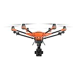
Equipped with a high-resolution camera, the H520E RTK captures sharp and detailed images necessary for accurate surveys. Its hot-swappable payload system allows for quick sensor changes, enhancing operational efficiency. The drone’s user-friendly interface simplifies mission planning and execution.
With a flight time of up to 30 minutes, the H520E RTK is suitable for medium-sized surveying projects. Its robust design and advanced features make it a reliable tool for professionals seeking high-quality data collection.
Pros:
-
High-resolution imaging
-
Integrated RTK module
-
Stable flight performance
-
Hot-swappable payloads
-
User-friendly interface
-
Robust construction
-
Reliable performance
-
Shorter flight time
-
Limited payload options
-
Higher price point
6. senseFly eBee X – Best Drone for Large Land Area Surveying Tasks
The senseFly eBee X is a fixed-wing drone designed for efficient surveying of expansive areas. Its lightweight design and long flight endurance make it suitable for large-scale mapping projects. The drone’s ability to work with various sensors enhances its versatility, providing a broad range of surveying capabilities.
With a flight time of up to 90 minutes, the eBee X can cover large areas in a single mission, reducing the need for multiple flights. Its RTK/PPK capabilities ensure high-precision data, making it ideal for accurate land surveys. The automated flight planning and data processing features help streamline workflows for surveyors.
The eBee X integrates with advanced cameras like the S.O.D.A. 3D mapping camera and the Parrot Sequoia multispectral sensor, allowing for topographic and vegetation analysis. This makes it a valuable tool for professionals handling large-area surveys. The drone’s efficiency and precision make it a top choice in the field.
Pros:
-
Long flight time
-
RTK/PPK capabilities
-
Versatile sensor compatibility
-
High-precision data collection
-
Automated flight planning
-
Ideal for large-area surveys
-
Streamlined data processing
Cons:
-
Sensitive to wind
-
Limited payload options
-
Expensive add-ons
7. WingtraOne GEN II – Long-Range Land Surveying Drone with VTOL
The WingtraOne GEN II is a versatile land surveying drone that excels in large-scale surveying missions requiring both precision and efficiency. It features a vertical takeoff and landing (VTOL) capability, making it ideal for surveying rugged or inaccessible terrains. Its fixed-wing design also allows for efficient coverage of large areas.
Equipped with a 42 MP Sony sensor, the WingtraOne GEN II provides incredibly detailed imagery for precise mapping. It integrates with photogrammetry software, streamlining the surveying process and speeding up project completion. Surveyors benefit from this drone’s easy deployment and adaptability to various surveying needs.
With a rugged build and minimal ground control points (GCP) required, the WingtraOne GEN II delivers professional-grade results, making it the go-to drone for agricultural, mining, and environmental surveys. Its efficiency and terrain adaptability make it a top choice for demanding projects.
Pros:
-
VTOL capability
-
42 MP camera
-
Long flight time
-
Survey-grade PPK
-
Rugged performance
-
Wide-area mapping
-
Minimal GCP required
Cons:
-
Expensive unit
-
Not compact
-
Requires operator training
8. Quantum Systems Trinity F90+ – Fixed-Wing Land Surveying Drone for Extended Coverage
The Quantum Systems Trinity F90+ is a fixed-wing drone engineered for extended surveying tasks over vast areas. With a flight time of up to 90 minutes, it can easily cover large tracts of land, making it perfect for mapping forests, farms, or coastal areas. The drone’s high-precision GNSS ensures accurate data collection even in challenging environments.
Equipped with PPK technology, the Trinity F90+ reduces the need for ground control points, improving post-processing accuracy. The automatic mission planning feature minimizes manual effort, allowing surveyors to focus on higher-level tasks. This drone’s performance and ease of use make it a preferred choice for large-scale surveying projects.
The Trinity F90+ strikes a balance between performance and usability, making it an excellent option for professionals who need reliable, consistent results. Its modular payload system adds flexibility for different surveying tasks, allowing for customization based on project needs.
Pros:
-
90-minute flight time
-
GNSS precision
-
Modular payload options
-
PPK enabled
-
Autopilot system
-
Durable airframe
-
Easy transport
Cons:
-
Fixed-wing size
-
Expensive upgrade
-
Requires launch space
9. DJI Matrice 300 RTK – Best Land Surveying Drone for Versatility and Payload Options
The DJI Matrice 300 RTK is a versatile surveying drone capable of carrying multiple payloads, including LiDAR, RGB, and thermal cameras. This makes it a great choice for a wide range of surveying tasks, from topographic mapping to infrastructure inspection. The drone’s 55-minute flight time allows for extended missions, reducing downtime.
Equipped with RTK and GPS integration, the Matrice 300 RTK ensures highly accurate geospatial data, essential for precise surveying. Its obstacle avoidance sensors and autonomous navigation capabilities enhance safety during operations. This drone is designed for professionals working on complex and high-demand surveying projects.
The Matrice 300 RTK’s adaptability, reliability, and high-performance features make it a favorite among surveyors. Whether for mining, utilities, or urban development, its versatility ensures it can handle various surveying challenges efficiently.
Pros:
-
Long flight time
-
Dual payloads
-
RTK and GPS integrated
-
Obstacle avoidance sensors
-
IP45 rating
-
Advanced AI tools
-
Reliable GPS
Cons:
-
Heavy build
-
Expensive payloads
-
Requires two operators
10. senseFly eBee X – Compact Fixed-Wing Land Surveying Drone
The senseFly eBee X is a compact fixed-wing drone perfect for medium-sized surveying tasks. It offers a maximum flight time of 90 minutes, covering up to 500 hectares in a single mission. Its ability to use hot-swappable payloads adds flexibility for various sensor options, enhancing its surveying capabilities.
With its lightweight build, the eBee X is easy to launch by hand, making it ideal for projects with limited ground support. The drone’s RTK/PPK options ensure accurate georeferenced imagery, allowing for precise data collection. Its intuitive software makes surveying more efficient and user-friendly, even for small teams.
This drone is a great choice for environmental monitoring, construction mapping, and other field projects that require reliable aerial data. Its portability and performance make it a valuable tool for surveying firms with limited resources.
Pros:
-
Hand-launch capability
-
90-minute flight time
-
RTK/PPK options
-
Lightweight design
-
Multiple sensor compatibility
-
Covers 500 hectares
-
Simple setup
Cons:
-
Sensitive to wind
-
Limited payload options
-
Expensive add-ons
11. Parrot Anafi Ai – Budget-Friendly Land Surveying Drone with 4G Connectivity
The Parrot Anafi Ai offers enterprise-level surveying capabilities at a more affordable price. It stands out with its 4G connectivity, enabling seamless real-time communication and control. Its 48MP camera provides excellent imagery for mapping tasks, ensuring detailed and accurate data.
This drone’s compact design and automated photogrammetry features make it suitable for new surveying professionals and small businesses. It integrates with Pix4D for fast data processing, streamlining the surveying workflow. The Parrot Anafi Ai is ideal for those looking to enter the drone surveying market without breaking the bank.
With AI-powered obstacle avoidance and quick setup, the Anafi Ai delivers efficient and reliable surveying results. Its affordability and ease of use make it a top choice for entry-level commercial drone surveying.
Pros:
-
Affordable price
-
48MP camera
-
4G connectivity
-
Lightweight frame
-
Quick setup
-
AI-powered avoidance
-
Pix4D compatibility
Cons:
-
Limited flight time
-
Not weatherproof
-
Small payload capacity
12. DJI Phantom 4 RTK – Entry-Level RTK Land Surveying Drone
The DJI Phantom 4 RTK is a compact and affordable drone that offers RTK-level precision for land surveying. Its built-in RTK module allows for centimeter-level accuracy, making it perfect for cadastral and construction surveys. Despite its small size, the Phantom 4 RTK delivers professional-grade results for a variety of surveying needs.
The drone features a 20MP camera, which captures high-quality imagery for mapping tasks. Its intuitive controller and easy setup make it user-friendly, particularly for smaller teams or solo operators. The Phantom 4 RTK integrates with the DJI GS RTK app for mission planning, further enhancing productivity.
For those looking to enter the surveying industry, the Phantom 4 RTK strikes a perfect balance between affordability and precision. It’s a reliable choice for both urban and rural surveying projects.
Pros:
-
Built-in RTK module
-
20MP camera
-
Easy control
-
Affordable price
-
Quick launch
-
Great accuracy
-
Compact design
Cons:
-
No swappable payloads
-
Short range
-
Not modular
13. Autel Robotics EVO II Pro – Best Drone For Land Surveying With 6K Camera
The Autel Robotics EVO II Pro is a powerful land surveying drone with an impressive 6K camera. This camera offers incredibly detailed imaging, essential for capturing accurate surveying data over large areas. The drone also incorporates advanced GPS technology, providing reliable positioning for surveying tasks in various environments.
With an extended flight time of up to 40 minutes, this drone enables surveyors to cover larger plots of land without interruptions. The advanced obstacle avoidance system further ensures the drone can safely operate in complex terrains while gathering data. As one of the best drones for land surveying, the EVO II Pro is equipped with high-end features suited for professional-grade surveys.
Its ability to perform precise mapping tasks makes it a go-to option for land surveying professionals. The drone’s lightweight design and compact build also make it portable, ideal for fieldwork. Surveyors looking for a balance of performance and portability will find the EVO II Pro to be an excellent choice for surveying tasks.
Pros:
-
6K camera
-
Long battery life
-
Advanced GPS
-
Obstacle avoidance
-
Portable design
-
Reliable control
-
Efficient mapping
Cons:
-
Expensive
-
Heavy
-
No RTK
14. Parrot Anafi USA – Best Drone For Land Surveying With Thermal Imaging
The Parrot Anafi USA is an innovative land surveying drone equipped with both thermal and optical cameras. This dual-camera setup ensures that surveyors can work under various conditions, from day to night, while still obtaining clear and precise data. Thermal imaging becomes a crucial feature in identifying land features and anomalies that might not be visible through regular optical cameras.

The drone’s ability to capture 4K HDR videos further enhances its ability to collect detailed data during surveys. With a 32x zoom, it allows surveyors to examine hard-to-reach areas with great detail, ensuring comprehensive survey data. The Parrot Anafi USA is an ideal solution for land surveying in environments that require a combination of optical and thermal data.
Thanks to its lightweight and easy-to-use controls, the Anafi USA is also a highly accessible drone for surveying professionals. Its extended flight time and ability to operate in various weather conditions make it a reliable option for surveying projects. As one of the best drones for land surveying, the Anafi USA excels in versatility and performance.
Pros:
-
Dual cameras
-
32x zoom
-
Thermal imaging
-
4K HDR video
-
Long flight time
-
Lightweight
-
High detail
Cons:
-
Expensive
-
Limited range
-
No RTK
15. DJI Matrice 300 RTK – Best Drone For Land Surveying With RTK Integration
The DJI Matrice 300 RTK is a top-tier land surveying drone that incorporates RTK (Real-Time Kinematic) technology for centimeter-level accuracy. This feature ensures that surveyors can trust the data they capture for high-precision tasks. With advanced autonomous flight capabilities, the Matrice 300 RTK allows for safe and efficient surveying, especially in challenging environments.
The drone’s modular payload design supports various sensors, such as LiDAR and high-definition cameras, enabling it to capture comprehensive survey data. It also has the capability to carry additional surveying tools, enhancing its versatility. Surveyors can confidently use the Matrice 300 RTK for detailed and reliable land surveying over large areas.
With its rugged build, extended flight time, and precise GPS capabilities, the Matrice 300 RTK is one of the best drones for land surveying. It is specifically designed for professional use, ensuring top-notch performance and data reliability. This drone is a great choice for those requiring a high level of surveying accuracy.
Pros:
-
RTK integration
-
Modular payloads
-
Long battery life
-
Autonomous flight
-
Rugged design
-
High precision
-
Reliable control
Cons:
-
High cost
-
Heavy
-
Complex setup
16. SenseFly eBee X – Best Drone For Land Surveying With Fixed-Wing Design
The SenseFly eBee X is a fixed-wing land surveying drone that offers exceptional endurance for covering vast areas. With the ability to fly for up to 90 minutes, this drone enables surveyors to complete long-distance land surveys without interruptions. Its fixed-wing design also makes it highly efficient in terms of energy use, allowing for extended flights over larger terrains.
Equipped with high-resolution cameras, the eBee X ensures that surveyors get the detailed survey data needed for accurate land mapping. It’s particularly ideal for surveying in large, open areas where drone endurance is crucial. This makes the SenseFly eBee X one of the best drones for land surveying, providing reliable data collection for topographic surveys.
Its lightweight, foldable design allows for easy transport, which is a key advantage for surveyors working in the field. The eBee X is compatible with various payloads, making it a versatile choice for different types of surveying projects. The fixed-wing design, coupled with its long flight time, makes it a great tool for professional land surveying tasks.
Pros:
-
Long flight time
-
High-resolution cameras
-
Efficient energy use
-
Large area coverage
-
Lightweight
-
Versatile payloads
-
Easy transport
Cons:
-
Expensive
-
Requires space
-
Complex operation
17. Delair UX11 – Best Drone For Land Surveying With High-End Precision
The Delair UX11 is a high-end land surveying drone known for its precision and accuracy. It integrates GNSS-based technology, offering centimeter-level positioning, which is essential for detailed surveying work. This level of accuracy ensures that the data captured is reliable and precise, especially for large-scale land surveys.
Designed for industrial applications, the Delair UX11 features an automated workflow, making it efficient for surveyors to handle multiple tasks at once. With its ability to capture high-quality imagery, it’s ideal for creating detailed land surveys. The UX11 is one of the best drones for land surveying, offering excellent value for professionals in the industry.
The drone’s rugged design allows it to handle tough environments, while its long endurance ensures that surveying tasks can be completed efficiently. The Delair UX11’s performance makes it a great investment for professionals who need high-precision data for surveying projects. Surveyors can rely on the UX11 for reliable and accurate land surveying every time.
Pros:
-
GNSS technology
-
High precision
-
Automated workflow
-
Long battery life
-
High-quality imagery
-
Rugged design
-
Reliable control
Cons:
-
High price
-
Complex setup
-
Requires expertise
18. Skydio 2 – Best Drone For Land Surveying With Advanced Obstacle Avoidance
The Skydio 2 is a highly intelligent land surveying drone with advanced AI-powered obstacle avoidance. This makes it perfect for operating in environments with numerous obstacles, such as trees or buildings. Surveyors can confidently use the Skydio 2 to navigate complex terrains while ensuring safe and efficient surveying data collection.
Equipped with a 4K camera, the Skydio 2 captures high-quality visuals that are essential for land surveying. Its autonomous flying capabilities further make it easy to collect data, even in hard-to-reach areas. The Skydio 2’s combination of safety, precision, and ease of use makes it a standout in the best drones for land surveying.
With a strong battery life and the ability to fly autonomously, the Skydio 2 ensures surveyors can complete surveying tasks efficiently. Its lightweight design also makes it an excellent choice for surveyors who need to transport the drone easily. This drone is one of the best options for those looking for a combination of advanced features and reliability.
Pros:
-
AI navigation
-
4K camera
-
Obstacle avoidance
-
Autonomous flight
-
Durable design
-
Intuitive controls
-
Reliable performance
Cons:
-
Expensive
-
Limited payload
-
Shorter range
19. DJI Matrice 210 RTK V2 – Best Drone For Land Surveying With Dual Payload Capability
The DJI Matrice 210 RTK V2 is a high-performance land surveying drone that supports dual payloads, such as optical and thermal cameras. This feature enables surveyors to gather multiple types of data in a single flight, improving the efficiency of land surveying tasks. The RTK technology further ensures that the data captured is highly accurate, providing precise survey results.
With a robust design, the Matrice 210 RTK V2 is built to handle various surveying tasks, even in challenging environments. Surveyors benefit from its long flight time, which allows for extended surveying sessions without the need for frequent recharging. Its dual payload feature and RTK integration make it one of the best drones for land surveying professionals.
This drone also offers intelligent flight modes that enhance its ease of use and improve surveying efficiency. The Matrice 210 RTK V2’s ability to adapt to different surveying needs makes it a versatile and reliable tool. Whether for topographical or environmental surveys, this drone is a top choice for land surveying professionals.
Pros:
-
Dual payloads
-
RTK system
-
Long battery life
-
Rugged design
-
Intelligent flight modes
-
High precision
-
Reliable control
Cons:
-
Expensive
-
Heavy
-
Complicated setup
20. Quantum Systems Trinity F90+ – Best Drone For Land Surveying With LiDAR Capability
The Quantum Systems Trinity F90+ is a cutting-edge land surveying drone equipped with LiDAR technology for detailed 3D mapping. This feature allows surveyors to capture highly accurate elevation and topographic data, making it invaluable for complex land surveys. The drone’s LiDAR capabilities enhance its ability to capture detailed data in challenging environments, such as dense forests or uneven terrains.
With a remarkable flight time of up to 90 minutes, the Trinity F90+ allows surveyors to cover vast areas without the need to recharge. Its long-range capabilities further enhance its ability to survey expansive regions efficiently. The Trinity F90+ is one of the best drones for land surveying, offering precision and efficiency for large-scale land projects.
The LiDAR technology, combined with the drone’s durable design and advanced features, makes the Trinity F90+ a top choice for land surveying professionals. Surveyors can rely on this drone for capturing high-quality survey data, ensuring accurate and reliable results every time. For those needing the best drone for surveying large or challenging landscapes, the Trinity F90+ is an excellent option.
Pros:
-
LiDAR technology
-
Long endurance
-
High precision
-
3D mapping
-
Long range
-
Robust design
-
Detailed elevation data
Cons:
-
Very expensive
-
Heavy
-
Requires training
Buyer Tips For Choosing The Best Drone For Land Surveying
Whether you’re new to aerial mapping or an experienced surveyor seeking an upgrade, this guide will help you choose the perfect Drone for Land Surveying for your needs.
1. Consider Flight Time and Coverage Area
When choosing the best Drone for Land Surveying, one of the most critical factors is flight time and coverage area. Drones with longer flight times, such as the senseFly eBee X, allow surveyors to cover larger areas without frequent battery changes.
Look for a drone that can cover substantial land areas in a single flight to maximize productivity and reduce operational costs.
2. Check for High-Precision GNSS and RTK/PPK Capabilities
For accurate land surveying, the precision of the data collected is paramount. A drone equipped with GNSS (Global Navigation Satellite System) and RTK (Real-Time Kinematic) or PPK (Post-Processed Kinematic) ensures precise positioning and mapping.
These technologies significantly enhance the quality of the data, especially in large-scale land surveying projects.
3. Look for Versatility in Payload Options
Different land surveying tasks may require different sensors and cameras. Ensure that the drone you choose has versatile payload options that can carry high-resolution cameras, multispectral sensors, or LiDAR units.
This flexibility will allow you to tackle various surveying tasks efficiently, whether you’re working on agriculture, topographic mapping, or infrastructure inspection.
4. Evaluate the Durability of the Drone
The best drone for land surveying should be durable enough to withstand harsh environmental conditions. Look for features like rugged airframes and weather-resistant builds, especially if you’re working in challenging terrain.
A durable drone ensures that your surveying equipment remains functional, even in adverse conditions, extending the lifespan of your investment.
5. Consider Easy Deployment and Automated Features
Time is of the essence in land surveying. A drone with easy deployment and automated features, like the WingtraOne GEN II, can save you time on the ground and streamline operations.
Features like automated flight planning, georeferencing, and data processing minimize manual labor, making the surveying process more efficient and less error-prone.
6. Check for Compatibility with Surveying Software
Ensure that the drone you choose is compatible with industry-standard surveying software, such as Pix4D or DJI Terra. Compatibility with these platforms allows for easy data processing and integration, enabling quicker analysis and reporting for land surveying projects.
It’s essential for surveyors to have a seamless workflow from flight to data processing.
7. Assess the Total Cost of Ownership
When purchasing the best drone for land surveying, it’s important to consider the total cost of ownership, including the purchase price, additional sensor or camera costs, maintenance, and software fees.
While high-end drones may be expensive initially, they can deliver high-quality data and save you money in the long run by improving the efficiency of your land surveying operations.
Best Drone For Land Surveying FAQs
-
What makes a drone suitable for land surveying?
A drone is suitable for land surveying when it offers high accuracy, long flight time, and the ability to carry various surveying equipment like RTK/PPK systems, cameras, or LiDAR sensors. These features enable precise data collection over large areas. -
What is the importance of RTK technology in land surveying drones?
RTK (Real-Time Kinematic) technology improves geospatial accuracy by correcting satellite signals in real-time. This allows surveyors to obtain centimeter-level precision, essential for accurate mapping and surveying tasks. -
How long can the Best Drone for Land Surveying fly?
The flight time of land surveying drones varies, but the Best Drone for Land Surveying typically offers between 45 to 90 minutes of flight time. Longer flight times allow for surveying larger areas in a single mission, increasing efficiency. -
What payloads can the Best Drone for Land Surveying carry?
The Best Drone for Land Surveying can carry various payloads such as cameras (RGB, multispectral), LiDAR sensors, and other surveying instruments. This flexibility allows for specialized data collection, including vegetation analysis and topographic mapping. -
Is a high-resolution camera important for land surveying drones?
Yes, a high-resolution camera is crucial for capturing detailed imagery during land surveying. It enables surveyors to create high-quality maps and models for precise analysis, which is essential in fields like agriculture, construction, and urban planning. -
Can land surveying drones handle challenging terrains?
Many of the best drones for land surveying, such as the WingtraOne GEN II, are designed to handle rugged and inaccessible terrains. Features like vertical takeoff and landing (VTOL) help these drones operate in difficult conditions, making them highly versatile. -
How much does the Best Drone for Land Surveying cost?
The cost of the Best Drone for Land Surveying can vary significantly depending on the features and technology included. Entry-level models may start around $1,000, while more advanced drones with RTK, LiDAR, and other high-end sensors can cost $10,000 or more
Conclusion
In conclusion, selecting the Best Drone for Land Surveying requires careful consideration of factors such as flight time, precision, and payload capacity. After evaluating various options, the senseFly eBee X stands out as the top choice due to its exceptional flight time, coverage, and high-precision GNSS capabilities.
This drone provides efficient and reliable data collection for large-scale surveying projects, making it a top pick for professionals in the field.
The Runner-Up in this category is the WingtraOne GEN II, which excels in versatility and terrain adaptability. Its ability to handle rugged environments and its powerful payload options make it an excellent choice for professionals working in challenging conditions.
While it may be pricier than other options, the WingtraOne offers unmatched performance in demanding land surveying tasks.
In summary, both the senseFly eBee X and WingtraOne GEN II are exceptional drones for land surveying, each excelling in different aspects.
The eBee X offers unmatched efficiency in large area coverage, while the WingtraOne stands out for its adaptability and advanced technology. Both are highly capable, but your choice will ultimately depend on the specific needs of your land surveying projects
Recent Posts
The best fertilizer for Aechmea fasciata is essential for promoting vibrant bract coloration, strong root systems, and steady vegetative growth throughout the active season. Selecting fertilizers...
The best fertilizer for landscaping is essential for maintaining lush lawns, vibrant plants, and healthy soil structure across diverse outdoor environments. Selecting fertilizers with NPK ratios such...